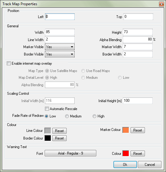
Track Map Properties
The form contains the following:
Position related properties
- Left and Top (textbox) – These are the coordinates of the left and top border of the control. If you enable the Internet map overlay, these two coordinates must be divisible by eight. if they aren't software will automatically adjust them.
General properties
- Width (textbox) – the width of the control (read only)
- Height (textbox) – the height of the control (read only)
- Line width (textbox) – you can set the width of the line used to draw the track
- Alpha Blending - controls the intensity of the control and limits the visibility.
- Marker visible (combo box) – there are two options
- Yes – the present position of the vehicle is indicated by a marker
- No - the present position of the vehicle is not indicated
- Marker width (textbox) – the width of the marker
- Boarder visible (combo box) – there are two options
- Yes – a boarder around the control is visible during run time
- No – a boarder around the control is not visible
- Boarder width (textbox) – the width of the boarder
Map related properties
- Map Type - there are two options
- Use Satellite Maps - the satellite maps are used when indicating the map area
- Use Road Maps - the road maps are used when indicating the map area
- Map Detail Level - there are two options
- High - the maps are of very high quality
- Medium - the maps are of medium quality
- Low - the maps are of low quality
- Alpha Blending - controls the intensity of the map and limits the visibility.
Scaling properties
- Automatic rescale (check box) – if automatic rescale is enabled, the control will rescale such that the whole track is displayed
- Initial width (textbox) – you can set the initial width of the area displayed by the track map window in meters
- Initial height (textbox) – you can set the initial height of the area displayed by the track map window in meters
- Fade rate of redraw (radio buttons) – the following options are available
Colour properties
- Line Colour – the colour of the track
- Boarder Colour – the colour of the boarder
- Marker Colour – the colour of the marker
Warning Text
Allows you to configure properties of the warning text that is displayed inside the track map control. Warning massages may appear due to several reasons; for example,
- If the vehicle is outside the defined map area or
- If the GPS signal is lost etc.
- Font – This is used to change the font properties.
- Colour – This is used to change the colour of the selected font